
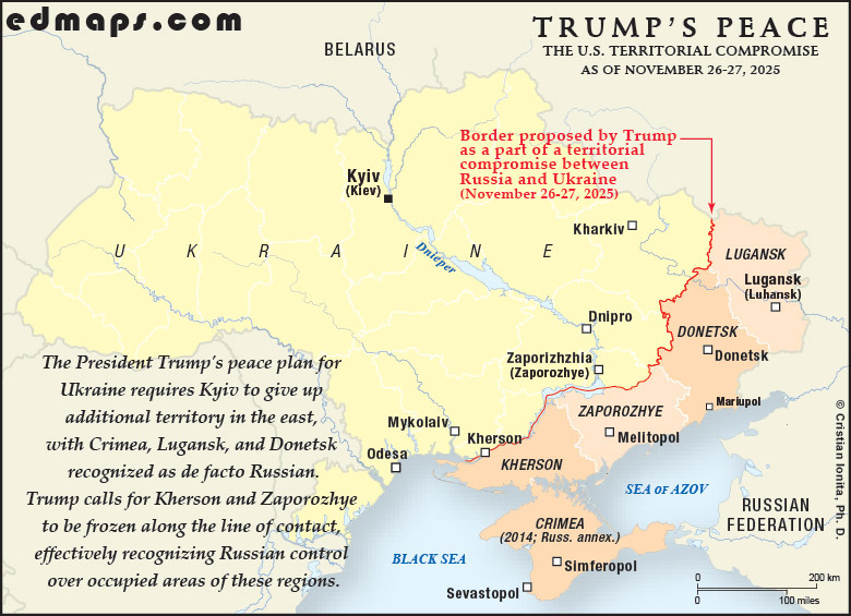
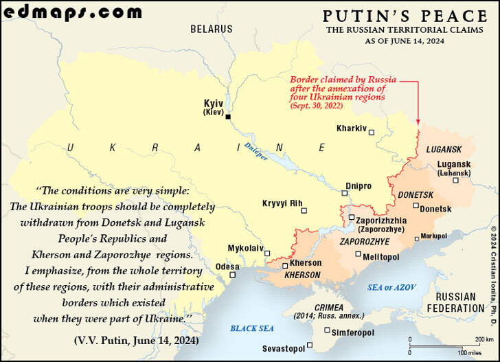
This page presents an original historical map illustrating the Russian annexation of southeastern Ukrainian territories in September 2022. Following internationally disputed referendums conducted in territories partially occupied during the Russian-Ukrainian War, the Russian Federation proclaimed the annexation of the Donetsk, Luhansk, Kherson, and Zaporizhzhia regions, significantly escalating the conflict and challenging the principles of territorial sovereignty established under international law. Designed for educational use, the map offers a clear visual representation of the territorial claims and political realities that emerged during a pivotal phase of the war.
See also :
Historical Maps of Ukraine — original historical maps of Ukraine;
More Historical Maps of Ukraine — curated links to historical maps and resources covering Ukrainian history;
The Ukrainian Lands after the Truce of Andrusovo (1667) — a map of the Ukrainian realm after the Russo-Polish War of 1654-1667;
Ukrainian People's Republic (1918) — a map of the Ukrainian state after the Treaty of Brest-Litovsk;
Soviet Ukraine in December 1922 — a map of the Ukrainian Soviet Socialist Republic in 1922.
In late September 2022, amid Russia's ongoing invasion of Ukraine, Moscow staged what international observers universally condemned as sham referendums in four partially occupied Ukrainian regions: Donetsk, Luhansk, Kherson, and Zaporizhzhia. Held from September 23 to 27, these hastily organized votes took place in areas where military hostilities continued and much of the original population had fled.
The referendums were illegal under international law and condemned by the United Nations as violations of the UN Charter. Reports emerged of election officials going door-to-door accompanied by armed soldiers, with residents facing pressure or intimidation to participate. Ukrainian President Volodymyr Zelenskyy characterized them as forced votes, claiming residents were sometimes compelled at gunpoint to support annexation.
Russian authorities reported implausibly high approval rates: over 98% in Donetsk and Luhansk, 93% in Zaporizhzhia, and 87% in Kherson. On September 30, 2022, President Vladimir Putin formally announced the annexation at a Kremlin ceremony, declaring Russia had acquired four new regions and calling their residents Russian citizens permanently.
The move represented the largest attempted annexation in Europe since World War II, encompassing roughly 90,000 square kilometers of Ukrainian territory—approximately the size of Portugal. Critically, Russia did not exercise full military control over any of these regions at the time of annexation.
The international community overwhelmingly rejected the annexation. The UN General Assembly voted 143 in favor, with only 5 against, to condemn Russia's actions. Only North Korea recognized the annexation's legitimacy. Ukraine immediately vowed to reclaim all occupied territory, and the annexation fundamentally escalated the conflict, with Putin suggesting Russia would defend these areas using all available means, including potential nuclear weapons.

‟[ ... ] I want everyone to remember this: the people living in Lugansk and Donetsk, in Kherson and Zaporozhye have become our citizens, forever.
We call on the Kiev regime to immediately cease fire and all hostilities, to end the war it unleashed back in 2014, and to return to the negotiating table. We are ready for this, as we have said more than once. But the choice of the people in Donetsk, Lugansk, Zaporozhye and Kherson will not be discussed. The decision has been made, and Russia will not betray it. Kiev’s current authorities should respect this free expression of the people’s will; there is no other way. This is the only way to peace.”
(V. V. Putin, Presidential address on the occasion of signing the treaties on accession of the Donetsk and Lugansk people’s republics and the Zaporozhye and Kherson regions to Russia, Moscow, September 30, 2022)

edmaps.com — Historical Cartography for Education
edmaps.com provides original maps and curated historical maps designed to support teaching, learning, and public understanding of territorial evolution and administrative history. The original maps are created by Dr. Cristian Ionita, and all curated maps are selected from public archives, historical collections, and private holdings, and are presented for educational and non‑commercial use.
© Cristian Ionita. All rights reserved.
Website: https://edmaps.com — Contact: info@edmaps.com